Planning
Visualisations for planning consultants
Pioneering visual solutions for the planning application process.
Planning consultants require accurate visualisations, that effectively communicate the scope and parameters of the projects they are promoting, at various stages of the planning process.
Our state-of-the-art visualisation services for planning and development projects empower planning consultants to both test and represent their projects with confidence. Each visualisation is crafted to meet local planning authority expectations, and by using the latest guidelines ensures that every planning application visual is accurate and clear.


We take a collaborative approach and recommend early engagement with skilled RTPI Planning Consultants, enabling them to quickly appraise and influence design work prior to application. This commitment to collaboration enhances the overall planning process experience for clients and consultant teams alike.

Addressing Key Planning Challenges
Our visuals address crucial planning considerations by:
- Illustrating visual effects from public viewpoints for townscape/landscape assessments
- Providing evidence of change in historic views or heritage asset settings to facilitate judgements around acceptable levels of harm
- Demonstrating cumulative visual effects of multiple proposed projects or ones consented but not yet built
While tools like VUCity or the use of Z mapping models benefit early project stages and rapid review, they cannot replicate real-world human perspectives—which is why Verified Views remain crucial for planning applications and securing committee approvals.
Enhanced Environmental Understanding
Our 3D modelling capabilities further enhance understanding of environmental effects through:
- Solar path diagrams showing expected shadow areas
- ZTVs (Zones of Theoretical Visibility) assisting in viewpoint selection
- Visual assessment techniques demonstrating screening effects of tree growth over time
This comprehensive approach illustrates to planning authorities how proposals would interact with surroundings, providing valuable insights for designers and decision-makers.

Visualisations for the planning process
Effective planning application visualisations

We craft planning application visualisations that meet rigorous regulatory standards. Our Accurate Visual Representations range from AVR levels 0 to 3, addressing various architectural project stages with height, scale, and mass visuals through to fully rendered, photorealistic Verified Views for applications, appeals and inquiries.

Our planning visuals address key challenges by illustrating impacts on public viewpoints, for townscape assessments. We provide evidence of change in heritage asset settings and demonstrate cumulative visual effects of multiple architectural projects—a critical consideration within changing urban development contexts.

While digital mapping tools benefit early architectural project stages, they cannot replicate real-world human perspectives. Our planning application visualisations remain crucial for development approvals, significantly contributing to success by showing how architectural projects will actually appear within existing sites.

Our 3D planning visuals enhance understanding of environmental effects through solar/shadow path diagrams, ZTVs (Zones of Theoretical Visibility) for viewpoint selection, and visualisation of screening effects over time. This comprehensive approach shows planning consultants how architectural proposals interact with surroundings, providing valuable decision-making insights.
We craft planning application visualisations that meet rigorous regulatory standards. Our Accurate Visual Representations range from AVR levels 0 to 3, addressing various architectural project stages with height, scale, and mass visuals through to fully rendered, photorealistic Verified Views for applications, appeals and inquiries.
Our planning visuals address key challenges by illustrating impacts on public viewpoints, for townscape assessments. We provide evidence of change in heritage asset settings and demonstrate cumulative visual effects of multiple architectural projects—a critical consideration within changing urban development contexts.
While digital mapping tools benefit early architectural project stages, they cannot replicate real-world human perspectives. Our planning application visualisations remain crucial for development approvals, significantly contributing to success by showing how architectural projects will actually appear within existing sites.
Our 3D planning visuals enhance understanding of environmental effects through solar/shadow path diagrams, ZTVs (Zones of Theoretical Visibility) for viewpoint selection, and visualisation of screening effects over time. This comprehensive approach shows planning consultants how architectural proposals interact with surroundings, providing valuable decision-making insights.
Collaboration for success in planning
Our collaborative approach to preparing visualisations for use in planning helps us maximise the advantages of our staged visualisation process.
Early Design Development
We help teams test and refine designs before wider stakeholder engagement. Our visuals enable review of early scheme proposals in an accessible format, ideal for pre-application enquiries and initial discussions with stakeholders.
Complex Environment Visualization
We illustrate the visual effects of cumulative schemes in rapidly changing environments. By showing how developments integrate with existing or future surroundings, we facilitate understanding of dynamic urban contexts.
Supporting Planning Decisions
Our high quality, accurate visualisations help decision makers understand proposals clearly. We demonstrate how screening effects and habitat changes develop over time as projects mature, addressing typical concerns proactively.
Enhancing Appeals & Inquiries
We create Verified Views that strengthen expert witness arguments during planning inquiries. Our visuals serve as persuasive evidence, reinforcing the case for favourable outcomes and supporting KC presentations effectively.

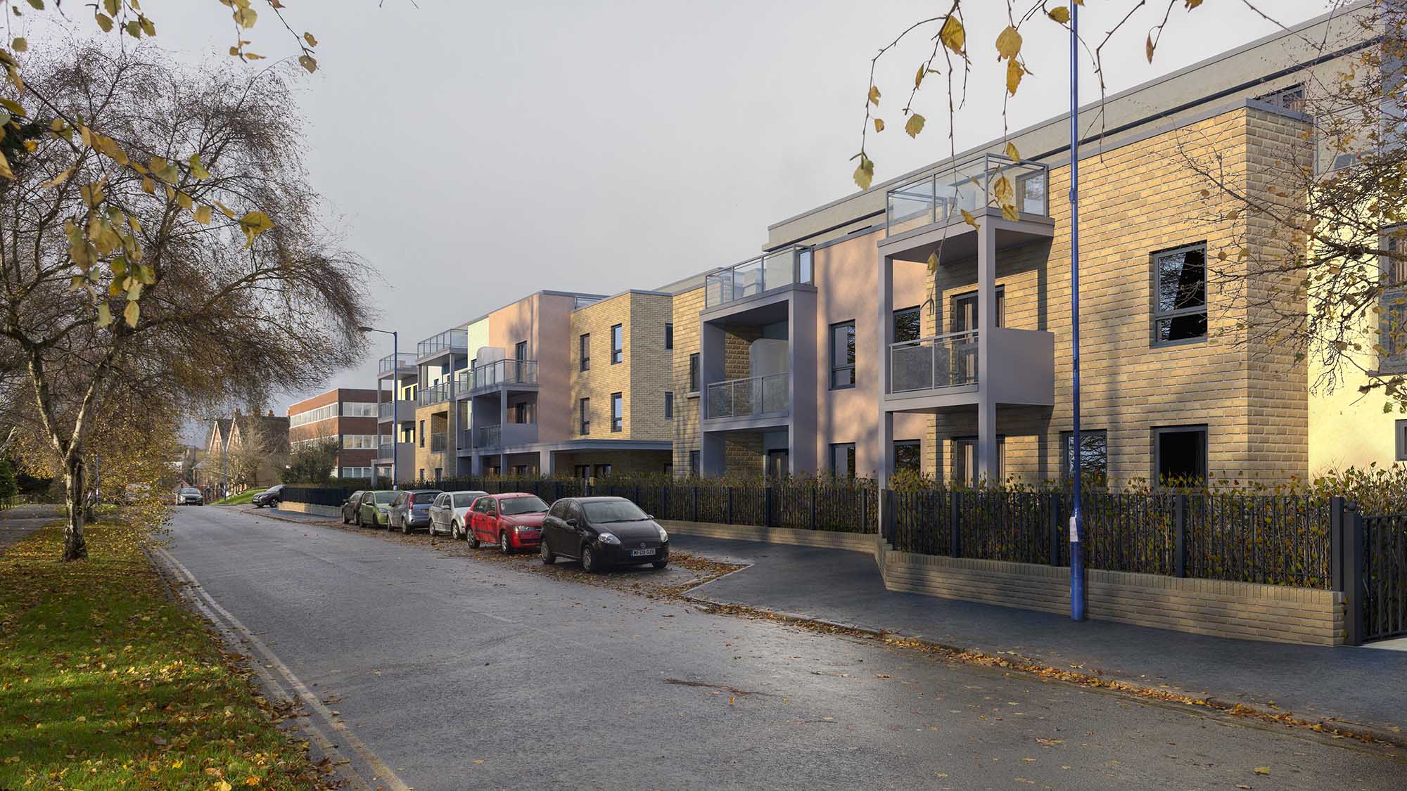
Caversham Road Existing View

Caversham Road Proposed AVR1 Accurate Visual Representation
Addressing technical challenges in planning visualisations
Every planning project visualisation requires a high degree of accuracy.

We ensure that every planning application visualisation we create meets the expectations of Planning Officers, Committees Members and community or statutory stakeholders. Our visuals are meticulously prepared to comply with local planning authority (LPA) requirements and adhere to relevant guidelines, ensuring reliability and effectiveness in the planning process.

Verified views need to meet the required standards set out by the Landscape Institute & various other planning and advisory bodies to ensure the visualisations are suitable for use in the planning process. We use high quality camera equipment, and where required use topographic surveying to ensure our visuals are accurate and fit-for-purpose.

Planning applications always have compressed deadlines involving multiple specialist, design and assessment consultants. We understand where our work fits in with the process and proactively collaborate with designers and planning consultants to ensure that their work and our visualisations are delivered in time for the critical stages of the planning submission.

Our visualisations are ideal for use in Design and Access Statements prepared in support of the planning applications. The use of compelling Concept Visuals or accurate Verified Views are also widely used in community consultations promoting the design and benefits of the project.

Having a folio of high quality ‘before and after’ visualisations from essential viewpoint locations add to the legibility and robustness of the professional judgements that are made in Landscape and Visual Impact Assessments (LVIAs), Townscape and Visual Impact Assessments (TVIAs) and Heritage Impact Assessments (HIA). Our visualisations serve as valuable evidence, helping decision makers understand the impact assessment judgements and supporting sound planning decisions.
We ensure that every planning application visualisation we create meets the expectations of Planning Officers, Committees Members and community or statutory stakeholders. Our visuals are meticulously prepared to comply with local planning authority (LPA) requirements and adhere to relevant guidelines, ensuring reliability and effectiveness in the planning process.
Verified views need to meet the required standards set out by the Landscape Institute & various other planning and advisory bodies to ensure the visualisations are suitable for use in the planning process. We use high quality camera equipment, and where required use topographic surveying to ensure our visuals are accurate and fit-for-purpose.
Planning applications always have compressed deadlines involving multiple specialist, design and assessment consultants. We understand where our work fits in with the process and proactively collaborate with designers and planning consultants to ensure that their work and our visualisations are delivered in time for the critical stages of the planning submission.
Our visualisations are ideal for use in Design and Access Statements prepared in support of the planning applications. The use of compelling Concept Visuals or accurate Verified Views are also widely used in community consultations promoting the design and benefits of the project.
Having a folio of high quality ‘before and after’ visualisations from essential viewpoint locations add to the legibility and robustness of the professional judgements that are made in Landscape and Visual Impact Assessments (LVIAs), Townscape and Visual Impact Assessments (TVIAs) and Heritage Impact Assessments (HIA). Our visualisations serve as valuable evidence, helping decision makers understand the impact assessment judgements and supporting sound planning decisions.

Orchid Place Retirement Living, Winter Proposed AVR3

Orchid Place Retirement Living, Winter Existing View

Orchid Place Retirement Living, Summer Existing View

Orchid Place Retirement Living, Summer Proposed AVR3
How we work
Planning consultants choose to work with NPA Visuals because of our proven track record.
Rigorous Accuracy
Our visuals are carefully developed to ensure they can be trusted as evidence during planning applications, appeals and inquiries
Collaboration
We work closely with planning consultants to ensure that the visuals we create are closely aligned with the project goals and overall planning objectives.
Effective Communication
Our visuals are designed to provide a clear, persuasive narrative to support planning applications, reassuring stakeholders and convincing planning committees.
Extensive Experience
We have extensive experience with design teams and clients working in sensitive locations on complex developments. Using the latest tools and best practices, we help planning consultants deliver favourable outcomes for their clients.


Want to learn more?
Our skilled team specialises in creating visualisations that empower planning consultants to achieve successful project outcomes.
Our visualisations play a vital role in understanding the impacts of developments, informing decisions, and fostering stakeholder confidence – all produced to the highest industry standards. Our collaborative approach ensures that planning consultants are at the heart of the creative process.