Landscape
Visualisations for Landscape Architects
Visuals that tell a story.
Landscape/ Townscape and Visual Impact Assessments assess the visual effects of proposed developments. Our Verified View Montages provide essential ‘before and after’ insights, allowing for confident professional judgments.
We specialise in high-quality Verified Views for urban and rural projects that enhance credibility of planning applications and Environmental Impact Assessment. Our portfolio includes urban renewal, infrastructure projects, sensitive landscape developments or restorations, multi-phase residential schemes, and habitat creation projects. We effectively visualise both large-scale developments and intricate designs, ensuring key aspects of the design are clearly represented.


Bath Western Riverside Existing View

Bath Western Riverside Proposed AVR3
Advanced visual appraisal techniques for Landscape Visualisations
We offer comprehensive viewpoint photography and visualisation services for landscape/townscape and visual appraisal or impact assessment.
Our clear, precise visuals empower Landscape Architects and design teams to advance projects and secure early, well informed stakeholder engagement.
With early involvement, we test potential visual effects by considering zones of theoretical visibility (ZTV), height, scale, mass positioning, and wireline options of designs.
This enables landscape architects to hone designs, refine options and identify impacts to avoid, early in the project lifecycle.

South Hooe River Tamar - Original View

South Hooe River Tamar - Year 10 Landscape Change Visualisation
Accurate, detailed photorealistic renderings for Landscape Visualisations
3D representations of landscape designs that involve elevation and terrain changes.
Our Accurate Visual Representations (AVR) showcase how proposed developments respond to and integrate with their local context.
Through sophisticated terrain modelling, we create precise 3D representations of landscape designs involving elevation changes and contour manipulation.
We specialise in visualising both hard and soft landscape elements combined with built form development.
Working with Landscape Architects, we can use species-accurate planting and habitat textures to demonstrate positive effects of well-designed landscapes.
For nuanced visualisation of landscape establishment and maturity, we can prepare seasonal views showing plant establishment and growth at key intervals.
We can also prepare visuals to inform night-time assessment.

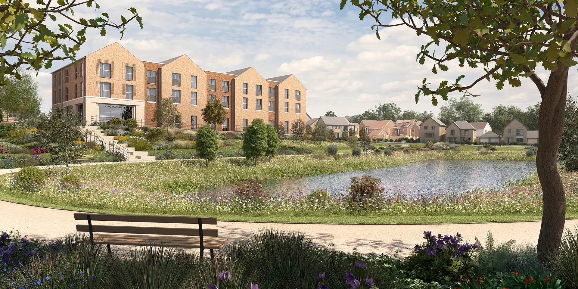
Forster Park Stevenage Existing View

Forster Park Stevenage Proposed AVR3 Year 1

Forster Park Stevenage Proposed AVR3 Year 5
How we work
We approach each landscape visualisation with a commitment to rigorous, process-based methodologies.

In visually complex urban environments, our visualisations capture exciting cityscape character while demonstrating effects of proposed design interventions. Our visuals help stakeholders understand how new design elements will change spaces and places.
For public realm projects, neighbourhood regeneration, or new urban developments, our concept images and detailed visuals show how designs integrate with and enhance their surroundings. In stakeholder consultations, a picture truly is worth a thousand words.

Garden design is often very personal process, but design for public or memorial gardens are for public benefit and involve lots of stakeholders. Our visualisations help communicate effectively your ideas for garden for celebration or memorial, reflection or relaxation. Your design ideas will be brought to life through our skill and experience in visualising garden spaces.

For heritage projects at Registered Parks and Gardens or Conservation Areas, preserving visual integrity through proposed change is paramount. Through 3D model testing or Verified Views, we demonstrate how restoration projects or infrastructure interventions integrate with designated sites.
Our successful track record of projects in sensitive locations comes from creating Verified Views that statutory stakeholders and heritage consultants rely on when assessing impact or harm. Visualisations inform design choices, helping project teams and Curators determine optimal intervention options and secure necessary consents.

Our visualisations capture the essence of National Landscapes, parks, and treasured natural environments. We understand these areas’ significance and unique characteristics, employing advanced techniques to showcase their beauty while illustrating potential visual effects of developments or conservation work.
For planning, community engagement, or conservation projects, our visualisations bring clarity to land use discussions. By highlighting key features and scenic views, we help stakeholders envision how changes interact with landscapes while fostering appreciation for these invaluable spaces.

Our plant form, species, and habitat textures illustrate ambitious ecological restoration projects clearly. Working with landowners, managers, ecologists and landscape architects, our realistic renderings depict anticipated naturalisation and succession outcomes.
Our visualisations showcase how sites and management proposals contribute to biodiversity and sustainability goals. We effectively communicate the visual appearance goals and anticipated long-term ecological benefits of rewilding and habitat creation, supporting stakeholder investment and public engagement.

By aligning our work with key UK guidelines, we ensure both clarity and relevance, these include:
- Landscape Institute’s Guidelines for Landscape and Visual Impact Assessment (GLVIA 3 & technical notes),
- NatureScot guidance for visual representation (formerly SNH), and
- the London View Management Framework (LVMF).
These standards outline Best Practices for visual representation, enabling us to uphold the highest professional standards in our work so that you can rely on our visualisations.

We handle all required photography site work safely and with necessary access permissions. While processing and cataloguing photography data for viewpoints, our team simultaneously create accurate terrain models and 3D digital models using your design information. Throughout, we maintain communication to keep project schedules updated and image iteration flowing, involving you in the image creation.
Our compositing process combines photography, 3D digital design models and survey information to accurately demonstrate how designs integrate with existing landscapes and built environments.
We guarantee technical precision in all verified visual representations. Our survey-verified photography anchors renderings in reality, providing genuine reliability that stakeholders can trust.
In visually complex urban environments, our visualisations capture exciting cityscape character while demonstrating effects of proposed design interventions. Our visuals help stakeholders understand how new design elements will change spaces and places.
For public realm projects, neighbourhood regeneration, or new urban developments, our concept images and detailed visuals show how designs integrate with and enhance their surroundings. In stakeholder consultations, a picture truly is worth a thousand words.
Garden design is often very personal process, but design for public or memorial gardens are for public benefit and involve lots of stakeholders. Our visualisations help communicate effectively your ideas for garden for celebration or memorial, reflection or relaxation. Your design ideas will be brought to life through our skill and experience in visualising garden spaces.
For heritage projects at Registered Parks and Gardens or Conservation Areas, preserving visual integrity through proposed change is paramount. Through 3D model testing or Verified Views, we demonstrate how restoration projects or infrastructure interventions integrate with designated sites.
Our successful track record of projects in sensitive locations comes from creating Verified Views that statutory stakeholders and heritage consultants rely on when assessing impact or harm. Visualisations inform design choices, helping project teams and Curators determine optimal intervention options and secure necessary consents.
Our visualisations capture the essence of National Landscapes, parks, and treasured natural environments. We understand these areas’ significance and unique characteristics, employing advanced techniques to showcase their beauty while illustrating potential visual effects of developments or conservation work.
For planning, community engagement, or conservation projects, our visualisations bring clarity to land use discussions. By highlighting key features and scenic views, we help stakeholders envision how changes interact with landscapes while fostering appreciation for these invaluable spaces.
Our plant form, species, and habitat textures illustrate ambitious ecological restoration projects clearly. Working with landowners, managers, ecologists and landscape architects, our realistic renderings depict anticipated naturalisation and succession outcomes.
Our visualisations showcase how sites and management proposals contribute to biodiversity and sustainability goals. We effectively communicate the visual appearance goals and anticipated long-term ecological benefits of rewilding and habitat creation, supporting stakeholder investment and public engagement.
By aligning our work with key UK guidelines, we ensure both clarity and relevance, these include:
- Landscape Institute’s Guidelines for Landscape and Visual Impact Assessment (GLVIA 3 & technical notes),
- NatureScot guidance for visual representation (formerly SNH), and
- the London View Management Framework (LVMF).
These standards outline Best Practices for visual representation, enabling us to uphold the highest professional standards in our work so that you can rely on our visualisations.
We handle all required photography site work safely and with necessary access permissions. While processing and cataloguing photography data for viewpoints, our team simultaneously create accurate terrain models and 3D digital models using your design information. Throughout, we maintain communication to keep project schedules updated and image iteration flowing, involving you in the image creation.
Our compositing process combines photography, 3D digital design models and survey information to accurately demonstrate how designs integrate with existing landscapes and built environments.
We guarantee technical precision in all verified visual representations. Our survey-verified photography anchors renderings in reality, providing genuine reliability that stakeholders can trust.


Want to learn more?
We create high quality visualisations for landscape architects to enhance concept and detail designs, and to reinforce LVIAs/TVIAs.
From concept images to photorealistic views, we showcase the evolution of landscape designs, ensuring clarity and precision, and helping teams achieve planning success and engage stakeholders for projects of all sizes.