
Verified Views – The Bigger Picture in Visual Assessment
Introduction
Verified Views have established themselves as essential tools within planning practice, most commonly supporting Landscape and Townscape Visual Impact Assessments or Heritage Impact Assessments. However, their potential extends far beyond traditional planning applications. Npavisuals applies this methodology across diverse scenarios, each demanding specific technical approaches and visual accuracy standards.
The key insight lies in understanding how different applications require different levels of visual detail whilst maintaining the fundamental accuracy and objectivity that makes Verified Views valuable. Whether supporting formal assessments or communicating design intent, the technical foundation remains consistent even as the application varies.
What makes this approach particularly powerful is its ability to present objective visual evidence that stakeholders can scrutinise and trust, regardless of the specific project context or assessment requirements.
Technical Foundation and Standards
Verified Views, also known as Accurate Visual Representations (AVRs), combine real-world photography, computer-generated imagery, and site-specific survey data to create objective representations of proposed developments within their settings. This methodology ensures that visual assessment becomes evidence-based rather than subjective.
Every Verified View must meet rigorous technical standards established by professional guidance. Photography follows Landscape Institute requirements for scale and accuracy, whilst the London View Management Framework provides four distinct AVR levels defining appropriate visual detail for different assessment purposes.
The technical methodology involves precise camera positioning using GPS coordinates, measured heights, and calibrated lens specifications. This survey-based approach eliminates perspective manipulation whilst ensuring that visualised proposals accurately represent their real-world appearance and scale relationships.
Supporting Planning Assessment Through Visual Evidence
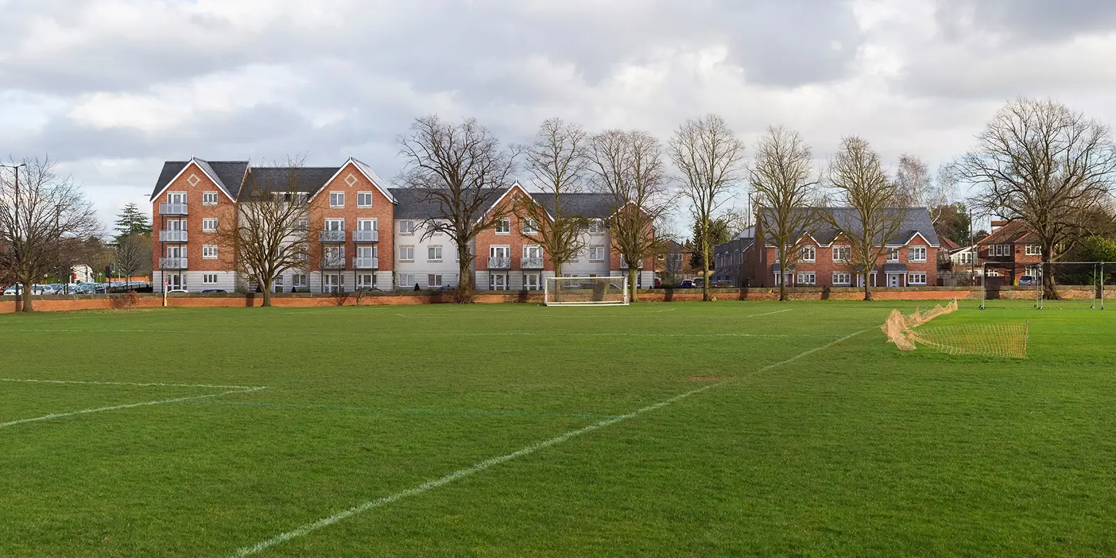
Within Landscape and Townscape Visual Impact Assessments, Verified Views provide clear evidence of how proposed schemes could visually affect their surroundings. The approach typically involves carefully captured photography prepared according to Landscape Institute guidelines, with viewpoints selected to represent key visual receptors.
Viewpoint selection requires strategic thinking about public access, visual sensitivity, and regulatory requirements. Parks, public spaces, transport corridors, and Rights of Way frequently provide appropriate vantage points. Panoramic images often prove valuable for showing wider contextual relationships that single-frame views cannot capture.
We find that involving qualified landscape architects in viewpoint selection, working alongside Local Planning Authority officers for pre-application consultation, produces more robust and defensible assessment frameworks. This collaborative approach ensures that visual evidence addresses genuine planning concerns rather than arbitrary locations.
For outline planning stages, AVR Levels 0-2 usually provide sufficient information for decision-making. However, more advanced planning stages benefit significantly from Level 3 photorealistic representations that help decision-makers and stakeholders understand proposals more clearly.
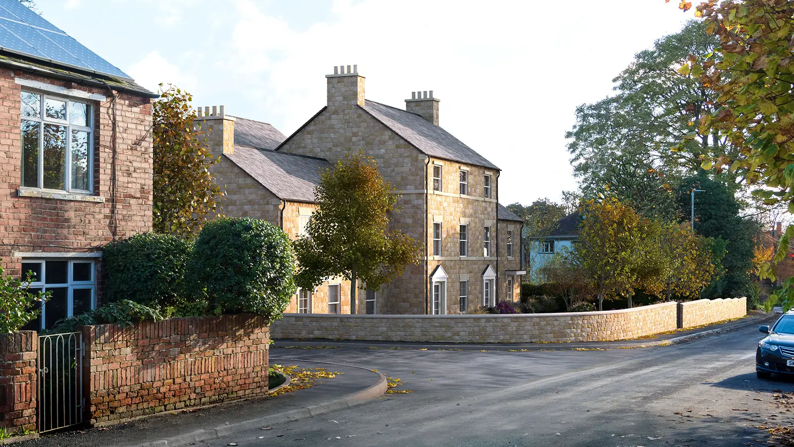
Heritage Assessment Applications
Heritage contexts present unique challenges where Verified Views test visual effects in relation to setting of heritage assets such as listed buildings, landmarks, or protected sightlines. These applications often focus on highly specific vantage points that relate directly to heritage significance rather than general public viewpoints.
Heritage perspectives might examine street views toward historic church spires, sightlines from landmark structures, or views that contribute to conservation area character. Heritage consultants typically provide the most appropriate guidance for viewpoint selection, though some authorities establish their own requirements like London’s View Management Framework
Our methodology adapts effectively across different UK contexts, with local planning authorities consulted to confirm relevant and sensitive viewpoints. This ensures that heritage assessment addresses locally significant views rather than applying generic approaches that might miss crucial visual relationships.
Technical accuracy becomes particularly critical in heritage assessment where subtle visual changes can significantly affect assessment outcomes. The ability to demonstrate precisely how proposed future development would relate to existing heritage assets provides essential evidence for planning decisions.
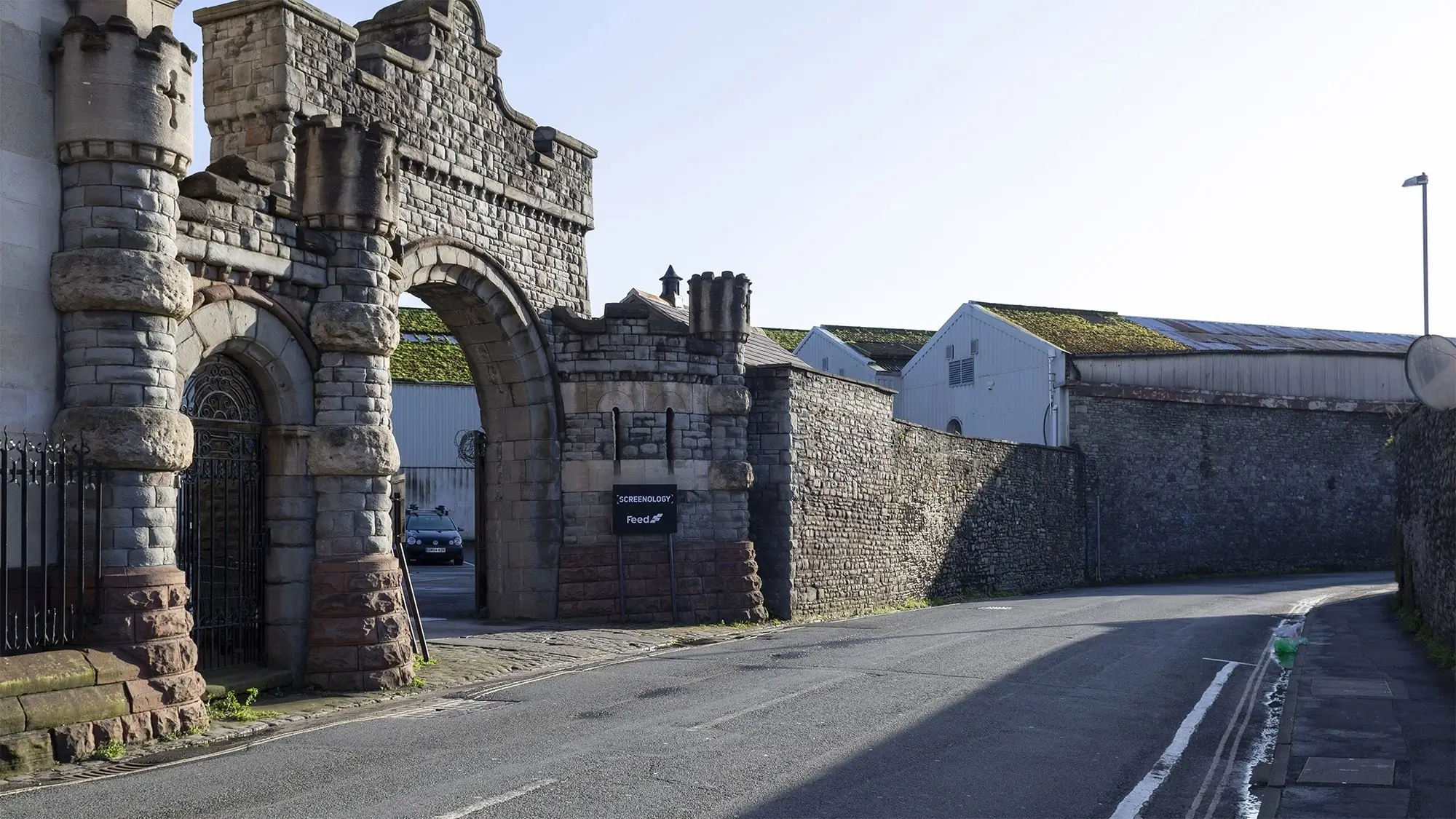
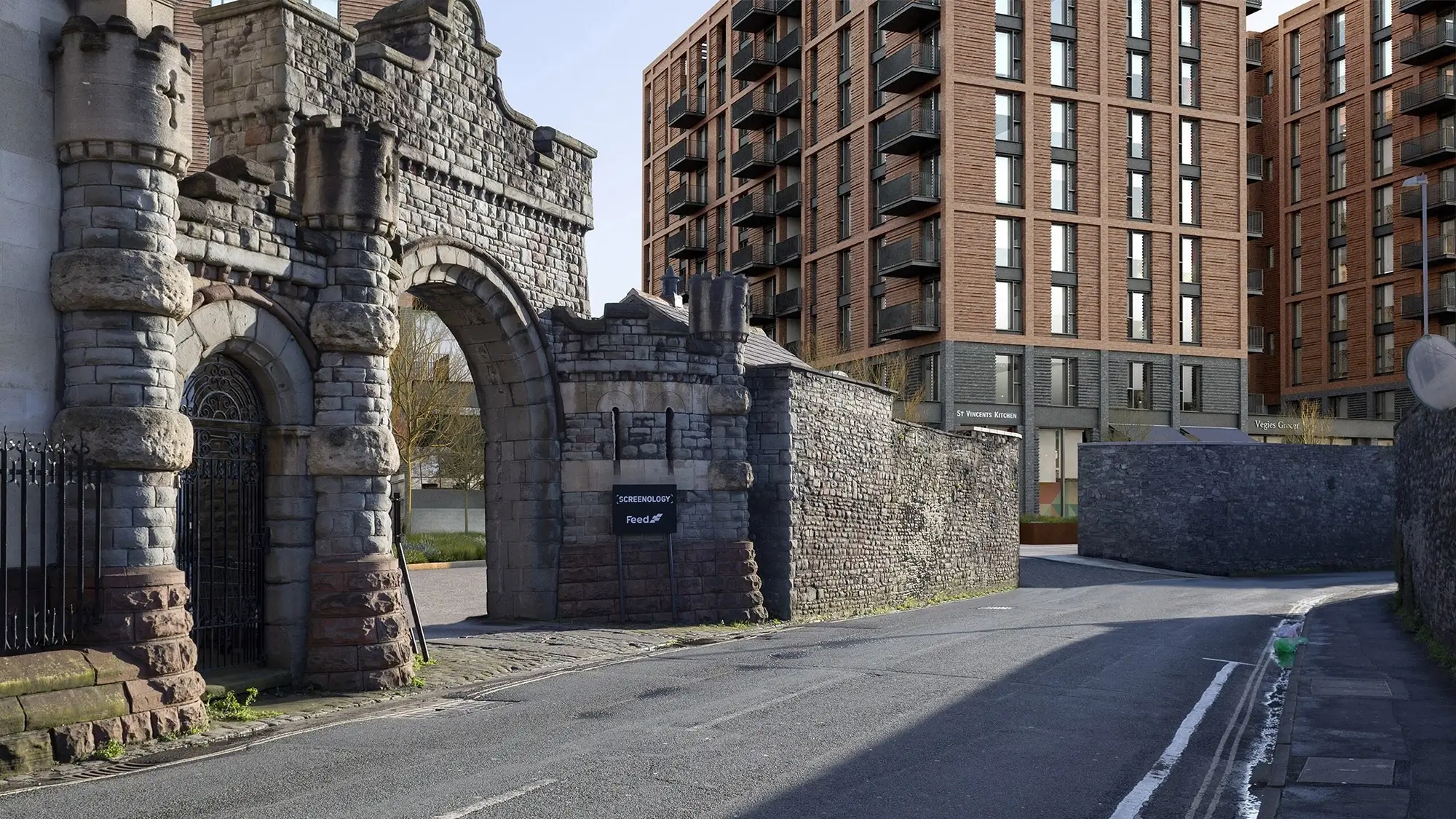
St Vincent Works Bristol
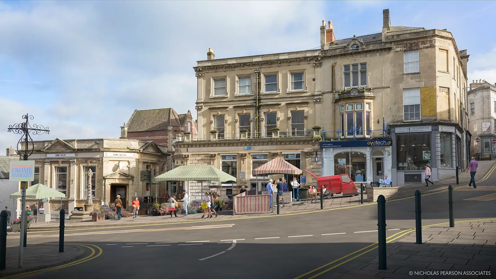
Frome Market Cross

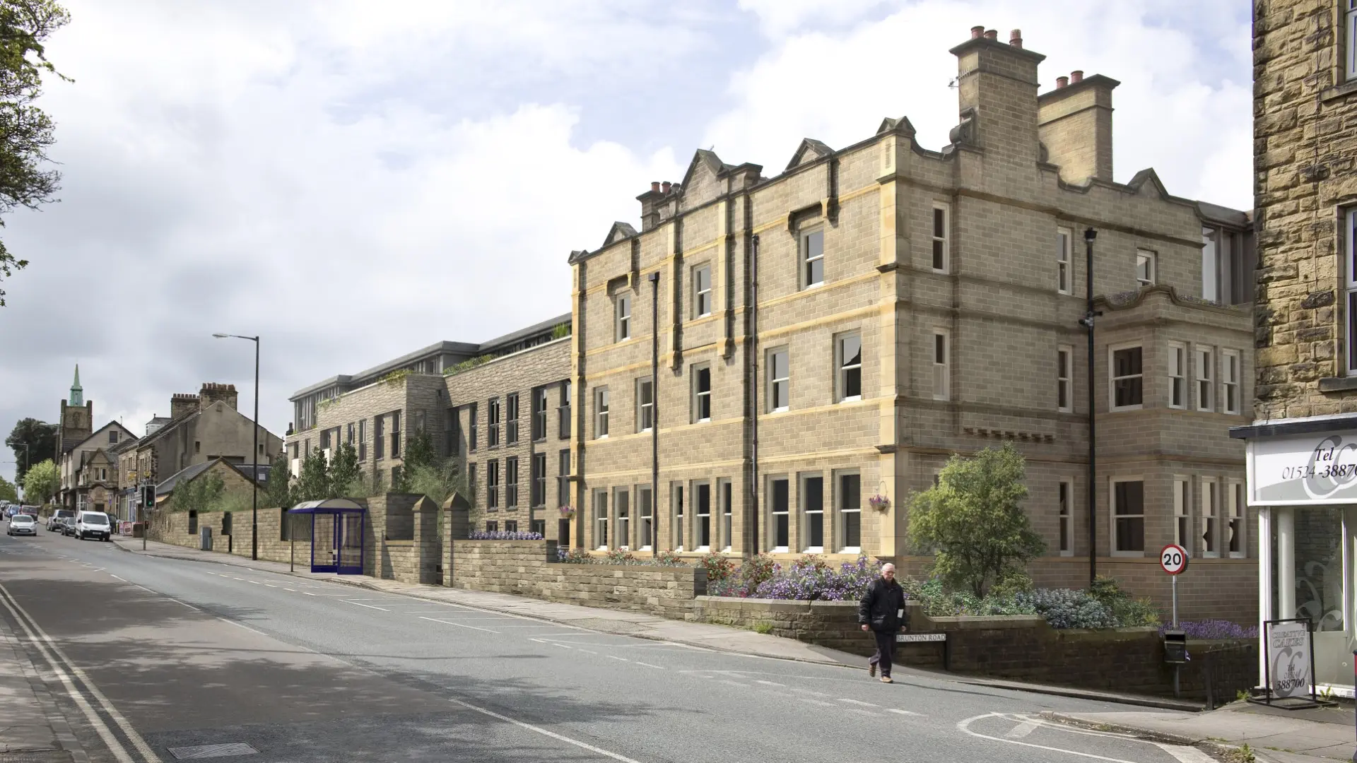
Design Communication Through Visual Realism
Beyond their assessment functions, Verified Views serve as compelling design communication tools. They highlight material choices, architectural details, and integration strategies, offering realistic impressions of how schemes will appear within their actual settings.
This application becomes particularly important in heritage or sensitive contexts where material appearance and finishing details face close scrutiny. Level 3 AVRs work most effectively for design communication, ideally developed through collaboration with project architects, landscape architects, and engineers to ensure their design work is captured and presented precisely.
The collaborative process ensures that visualised designs accurately represent intended construction details and material specifications. This prevents discrepancies between planning submission visualisations and approved designs that could undermine stakeholder trust or planning approval validity further down the line.
When communicating design, verified views maintain the same accuracy standards as used in assessment work whilst focusing on different visual outcomes. Rather than simply documenting visual effects and appearance, these visuals are used to demonstrate design quality and contextual integration strategies.
Flexible Applications Across Project Types
Professional experience reveals how Verified View methodology adapts across diverse project types whilst maintaining consistent technical standards. Residential developments, commercial schemes, infrastructure projects, and mixed-use developments each present unique visual challenges requiring tailored approaches.
Waterside locations often demand panoramic viewpoints capturing both immediate and distant visual relationships as well as reflections. Urban contexts typically focus on street-level perspectives that represent pedestrian experience. Rural settings require viewpoints from public access points that might be considerable distances from proposed development sites, or roads!
The flexibility lies in appropriate viewpoint selection and selecting techniques for presentation of visual detail rather than technical methodology. Whether supporting outline applications through massing studies or full applications through photorealistic representations, the underlying survey accuracy and perspective control remain constant.
This adaptability enables our methodology to serve early-stage feasibility studies through to full planning submissions or listed building applications and public inquiry evidence. Our approach provides consistent visual evidence throughout project development.
Quality Assurance and Professional Standards
Professional application of Verified Views demands understanding of both technical capabilities and appropriate deployment across different assessment contexts. Quality assurance involves ensuring that technical standards match application requirements whilst maintaining objectivity and accuracy in the preparation of the visualisation
The survey foundation must remain consistent regardless of visual detail levels or specific application purposes. Camera positioning, height measurements, and lens calibration require the same precision whether producing initial massing studies or detailed photorealistic representations.
We apply systematic quality control processes that verify survey accuracy, check perspective alignment, and validate material representation against specification documents. This ensures that visualisations reliably represent intended designs rather than creating artistic interpretations.
Professional standards also require clear communication about methodology, assumptions, and limitations. Stakeholders need to understand how visualisations were prepared, the parameters used, and what they represent to make informed decisions based on such visual evidence.
Technical Innovation and Future Development
Contemporary Verified Views practice increasingly incorporates advanced rendering technologies that improve material accuracy and environmental simulation. Physically-based rendering systems enable more realistic representation of complex materials, lighting interactions, and atmospheric effects.
Integration with survey technologies such as LiDAR scanning, and photogrammetry enhances both accuracy and efficiency. These tools enable more comprehensive site documentation whilst maintaining the precision that Verified Views require.
Technical advancement must however serve accuracy and objectivity rather than visual impressiveness or sensationalism. The fundamental purpose remains presenting reality as objectively as possible rather than creating compelling but potentially imagery misleading images.
Objective Visual Evidence
Whether supporting planning applications, heritage assessment, or communicating design intention, Verified Views provide uniquely powerful visual evidence. Their value derives from prioritising accuracy, impartiality, and technical rigour rather than just creating aesthetic appeal or manipulating persuasive imagery. They must allow designs to speak for themselves in that respect.
Our methodology serves as an objective mirror reflecting how proposed developments will actually appear within their settings. This objectivity enables stakeholders to make informed decisions based on reliable visual evidence rather than subjective interpretation or incomplete information.
Professional application requires understanding when different AVR levels serve specific purposes whilst maintaining consistent technical standards. The bigger picture encompasses not just what developments look like, but how visual evidence supports better decision-making across diverse planning and design contexts.
Conclusion
Uses for Verified Views extend far beyond traditional planning applications and can support comprehensive visual assessment across multiple disciplines and project phases. Their versatility stems from rigorous application of a robust technical methodology that adapts to different requirements whilst maintaining fundamental accuracy and objectivity.
Understanding how to apply this methodology appropriately across planning applications, heritage assessment, and design communication requires both technical expertise and practical experience. The future of visual assessment lies in recognising these broader applications whilst maintaining the rigorous standards that make Verified Views credible and defensible.
Professional Planning practice increasingly demands visual evidence that stakeholders can scrutinise and trust. Verified Views provide this evidence across diverse applications, supporting better decision-making through objective representation of proposed development impacts and design integration strategies.
Please contact us to discuss how our visualisation team can help you with your next project.